


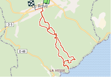
13 le Rove Les Esclales ruines cal figuerolle vallon Fontêtes

Nathy8913
User

Length
10.4 km

Max alt
214 m

Uphill gradient
332 m
Km-Effort
14.8 km

Min alt
18 m

Downhill gradient
318 m
Boucle
No
Creation date :
2023-05-04 11:44:10.853
Updated on :
2023-05-06 13:12:07.243
3h21
Difficulty : Difficult

FREE GPS app for hiking
 SityTrail
IGN / Geographical institutes
SityTrail Plus
The world is yours!
About
Trail Walking of 10.4 km to be discovered at Provence-Alpes-Côte d'Azur, Bouches-du-Rhône, Le Rove. This trail is proposed by Nathy8913.
Positioning
Country:
France
Region :
Provence-Alpes-Côte d'Azur
Department/Province :
Bouches-du-Rhône
Municipality :
Le Rove
Location:
Unknown
Start:(Dec)
Start:(UTM)
682386 ; 4804166 (31T) N.
Comments